History of Ancient Geography
Hindus have always been curious to know about and write about the world and its functions, whether social or scientific. Hindus were in that sense explorers, to pursue the unknown. For example, writing of ancient battles between supernatural beings were many times allegorical to warfare between political opponents, and describing tribes, such as the Kishkindha as monkeys or Sabaras as lions, were metaphors because those animals were official totemic symbols of the clans.
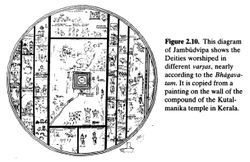
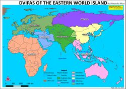
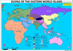
In terms of Geography, Hindu scriptures had divided the eastern world island consisting of 4 continents. Later it was generalized into 4 continents; namely Jambu-dvipa in the south, Uttara-Kuru in the north, Purva-Videha in the east, and Apara-Godaniya in the west. Jambu-dvipa is more or less synonymous with Bhārata (Indian Subcontinent) but the names and boundaries of the others are altered from time to time, to reflect the change of the political and cultural situations. Continent bordering with each other is based on Mount Meru being at the centre.
Most popular in scriptures were the lands in and adjacent to India.
| After Agnidhara, Jambu-dvipa was divided into nine regions (varṣas) and ruled over by one of these sons. Nabhi ruled over Hema-varṣa, Kimpurusha over Hemakunta-varṣa, Hari over Naishadha-varṣa, Ilāvṛta over Meru-varṣa, Ramya over Nilachala-varṣa, Hiranamana over Sveta-varṣa, Kuru over Shringa-varṣa, Bhadrasva over Malyavan-varṣa and Ketumala over Gandhamadana-varṣa. | ||
—Puranas | ||
The sages not only traveled frequently to lands outside of India but had also setup their hermitages in them, particularly on their mountains. They often traveled to them by way of rivers.
| And beyond that region is a river named Sailoda (Syr Darya), on both of whose banks grow the bamboo canes known as kicaka.
These carry the siddhas to and from the opposite shore, where lies the country of Uttara-Kuru, the refuge of those who have performed meritorious deeds. |
||
—Ramayana Kiskindhakāṇḍa 37-38 | ||
In many cases, the Indian sages also became royal advisors to the kings and their courts in these countries. Buddhayasas was a Kashmiri and had become the preceptor of Dharmagupta the king of Kashgar in 5th century CE. Gunavarman was a prince of Kashmir but was missionary for much of his life and became the royal adviser to the kings of East China, Java, and Sri Lanka in the 4th century CE. Even the Hindu Shahi Dynasty was established in the 9th century CE by the Turki Shahi Afghanistani dynasty's Brahman minister Kallar.[1] King Minar Dhitika of Afghanistan was converted to Buddhism by Sangabhadra. King Seve Salbar of Afghanistan was converted to Bonpo by Namse Chyitol. Zarathustra Spitama became the rajyaguru to King Vishtaspa of Balkh.
One common mistake made by many people is to conflate 1 place with another because of similar names. For example, there are 2 Mandakini rivers, 2 Narmada rivers, 2 Vindhya mountain ranges, 3 Gokarna tirths, 3 Potala tirths, multiple Dwarkas, and multiple 'Lankas'.
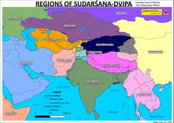
Sudarṣana-dvipa[edit]
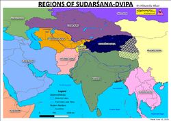
This continent, which is also known as 'gLing-bZhi' ('Chatur-dvipa' or Four Islands) in Tibetan, is located south of Mt. Meru.
It has four mountain ranges protruding from its central Mount Meru, which are known as vaksaskāra (tusks.) The Tibetan Bonpo scriptures also mention these ranges are "tusks."
Southern Provisions[edit]
Jambu-dvipa' refers to the Indian Subcontinent. The Mahabharata while naming 4 world continents, calls "Jamvu-dvipa otherwise called Bhārata." The Surya Siddhanta is the same way. The Vishnu Purana[2] recognizes Bhārata as the most sacred because it is the "karmabhumi" of spiritual practitioners, and it is also referred to as a "srestha-bhumi". Rajasekhara also divides his Kumari-dvipa (India) into five divisions; Udichyadesa (north), Madhyadesa (central), Purvadesa (east), Pachimdesa (west), and Daksinapatha (south.) Chinese pilgrims also divide the Subcontinent into "Five Indias."
This area most sacred to the Hindu scriptures of all sects, including Buddhist, Jain, and Bonpa, because here is where Hinduism prospered.
Besides Mt. Meru, the other venerated mountains in this continent are Kailash, which is also the name in the Mahabharata of "huge mountains of Hemakuta."[3] Jambu-sandha is its other name.
In Tibetan, it is known as both dZambu-ling and Hdsam-buhi-glifi (and the Chakravarti as Hdsambuhi-glin-gi-rgyal-po.)
The Subcontinent would go on to be recognized by Indians and the rest of the world by various names.
| Jambu-dvipa | Bhārata | Aryavarta | Hindustan | Hindistan | Hind | India |
|---|---|---|---|---|---|---|
| "This (Brahmaputra) is the eastern boundary of Jambu-dvipa, its western boundary being the mouths of the Indus and its southern boundary being the Indian Ocean or Rama Sethu." | "The country lying north of the ocean and south of the Himadri is Bhārata." | "In the west the boundary-river (Indus), in the east the region where the sun rises (Himalayas),—as far as the black antelopes wander (between these two limits.)" | "The empire of Hindustan is extensive, populous, and rich. On the East, the South, and the West it is bounded by the Great Ocean." | "East of it (Hindistān) are the countries of China and Tibet; South of it, the Great Sea; west of it, the river Mihran (Indus); north of it, the country of Shaknan belonging to Vakhan and some parts of Tibet."" | "the ard al-Hind is a vast country which extends itself on the sea, the continent and the mountains;..." | "The boundary of the land of India towards the north is Mount Taurus (Caucasus.) The western part of India is bounded by the river Indus right down to the ocean. Towards the south this ocean bounds the land of India, and eastwards the sea itself is the boundary." |
| Artha Shastra | Vishnu Purana[4] | Vasiśṭha Sutra[5] | Babernama | Hudud al-'Alam | Historical Encyclopedia | Indoi |
In addition to these names, India is also known as Kumari-dvipa (or Kumarika), Indostan, and Ajanabha-khanda. In the "Mahā Govinda Sutta" of Buddhist Digha Nikaya the shape of Mahā-pathavi (another name of India.) In one of the Buddhist Avadanas Asoka is stated to be the ruler of Jambu-dvipa, wherein the toponym is used for India. In the Buddhist Abhidharmakośa[6] the name Jambu-dvipa is used for India as well. The Sinhalese version for the term Jambu-dvipa is 'Dambadiva', as written by Nissamkamalla, in his Galpota inscription.
Based on cardinal directional[edit]
In Yaksha's era, the Subcontinent was thought of as divided into 3; Udichya (North), East (Prachya), and Dakshina (South.)[7] In the Dharma Shastra of Baudhayana there were also 3 recognized divisions of India. Then 5 zones were recognized.
The 5 divisions (Panchasthala) were Uttarapatha or Udichya (the North), Madhyadesa (the Middle Country), Purvadesa or Pracya (the East), Aparanta or Praticya (the West), and Daksinapatha (the South.)
Somadeva Silri refers to a six fold categorization of India, the Vayu Purana 8, and eventually with the Vishnu, Markendaya, and Matsya there were 9 divisions of India.
Based on ethno-political subdivisions[edit]
The Vishnu Purana[8] divides India into 9 upadvipas or zones; Indra-dvipa, Kaserumat, Tamravarna, Ghabhastimat, Naga-dvipa, Saumya, Gandharva, and Varuna. The 9th [unmentioned by name but described as] "is surrounded completely by the sea" (or "sagarasamurta"), and hence, is modern Sri Lanka.
Bhārata is not Bharata-varṣa. The distinction between the 2 is seen in the Mahabharata wherein in the enumeration of ethnicities within of the Bhārata, the peoples of Hari-varṣa (Kasmiras, Dardas, Niṣadhas, Khasiras, Darunas, Kamvojas, Yavanas, Sakas, Hunas, Parasikas, and Mlecchas) as well as those of Kimpurusha-varṣa (Kiratas, Mahabhutas, and Chinas) are included in the list.
| After this, listen to the names of the provinces as I mention them. They are the Kuru-Panchalas, the Salwas, the Madreyas, the Jangalas, the Surasena, the Kalingas, the Vodhas, the Malas, the Matsyas, the Sauvalyas, the Kuntalas, the Kasi-kosalas, the Chedis, the Karushas, the Bhojas, the Sindhus, the Pulindakas, the Uttamas, the Dasarnas, the Mekalas, the Utkalas; the Panchalas, the Kausijas, the Nikarprishthas, Dhurandharas; the Sodhas, the Madrabhujingas, the Kasis, and the further-Kasis; the Jatharas, the Kukuras, O Bharata; the Kuntis, the Avantis, and the further-Kuntis; the Gomantas, the Mandakas, the Shandas, the Vidarbhas, the Rupavahikas; the Aswakas, the Pansurashtras, the Goparashtras, and the Karityas; the Adhirjayas, the Kuladyas, the Mallarashtras, the Keralas, the Varatrasyas, the Apavahas, the Chakras, the Vakratapas, the Sakas; the Videhas, the Magadhas, the Swakshas, the Malayas, the Vijayas, the Angas, the Vangas, the Kalingas, the Yakrillomans; the Mallas, the Suddellas, the Pranradas, the Mahikas, the Sasikas; the Valhikas, the Vatadhanas, the Abhiras, the Kalajoshakas; the Aparantas, the Parantas, the Pahnabhas, the Charmamandalas; the Atavisikharas, the Mahabhutas, O sire; the Upavrittas, the Anupavrittas, the Surashatras, Kekayas; the Kutas, the Maheyas, the Kakshas, the Samudranishkutas; the Andhras,
There are other kingdoms, O bull of Bharata's race, in the south. They are the Dravidas, the Keralas, the Prachyas, the Mushikas, and the Vanavashikas; the Karanatakas, the Mahishakas, the Vikalpas, and also the Mushakas; the Jhillikas, the Kuntalas, the Saunridas, and the Nalakananas; the Kankutakas, the Cholas, and the Malavayakas; the Samangas, the Kanakas, the Kukkuras, and the Angara-marishas; the Samangas, the Karakas, the Kukuras, the Angaras, the Marishas: the Dhwajinis, the Utsavas, the Sanketas, the Trigartas, and the Salwasena; the Vakas, the Kokarakas, the Pashtris, and the Lamavegavasas; the Vindhyachulakas, the Pulindas, and the Valkalas; the Malavas, the Vallavas, the further-Vallavas, the Kulindas, the Kalavas, the Kuntaukas, and the Karatas; the Mrishakas, the Tanavalas, the Saniyas; the Alidas, the Pasivatas, the Tanayas, and the Sulanyas; the Rishikas, the Vidarbhas, the Kakas, the Tanganas, and the further-Tanganas. Among the tribes of the north are the Mlecchas, and the Kruras, O best of the Bharatas; the Yavanas, the Chinas, the Kamvojas, the Darunas, and many Mleccha tribes; the Sukritvahas, the Kulatthas, the Hunas, and the Parasikas; the Ramanas, and the Dasamalikas. These countries are, besides, the abodes of many Kshatriya, Vaisya, and Sudra tribes. Then again there are the Sudra-abhiras, the Dardas, the Kasmiras, and the Pattis; the Khasiras; the Atreyas, the Bharadwajas, the Stanaposhikas, the Poshakas, the Kalingas, and diverse tribes of Kiratas; the Tomaras, the Hansamargas, and the Karamanjakas. These and other kingdoms are on the east and on the north. O lord, alluding to them briefly I have told thee all. |
||
The Markandeya Purana includes Yavana, Parada, Kamboja, Darada, Pallava, Barbara, Vahlika, and Kashmira among ethnicities of India.
The Devi Bhagavatam, like the Dasa Sahitya[9] also classes India into 8 regions.
| The names of out and made these are: Svarnaprastha, Chandras'ukra, Âvartana, Ramânaka, Mandaropâkhya, Harina, Pânchajanya, and Ceylon. | ||
—Devi Bhagavatam, 8.11 [1] | ||
Mountainous chains[edit]
| Similarly, south of Ilāvṛta-varṣa and extending from east to west are three great mountains named (from north to south) Niṣadha, Hemakūṭa and Himālaya. Each of them is 10,000 yojanas [80,000 miles] high. They mark the boundaries of the three varṣas named Hari-varṣa, Kimpuruṣa-varṣa and Bharata-varṣa. | ||
—Srimad Bhagavatam 5.16.9 | ||
| Mountain ranges | Synonyms | Modern name | Defining varṣa |
|---|---|---|---|
| Himavat | Himavan (White Mountains), Hemasomodbhava |
Himalaya | Bharat-varṣa |
| Mahahimavan | Hemakuta (Golden Mountains) | Gangdise | Kimpuruṣ-varṣa |
| Niṣada | Krishnagiri (Black Mountains) | Karakoram | Hari-varṣa |
| Malyavan | Anila (Light Mountains) | Kunlun | Bhadrasva-varṣa |
| Nila | Nilagiri (Dark Mountains) | Hindu Kush | Ketumal-varṣa |
| Rukhmi | Sveta (White Mountains) | Pamir | Ramyak-varṣa |
| Sringavat | Aruna (Brown Mountains), Sikhari | Tian Shan | Uttar-Kuru |
| Water body | Synonyms | Modern name |
|---|---|---|
| Sindhu | Alakananda | Indus |
| Sita | Bhadrasoma | Yarkant |
| Bhadra | Sitoda, Sailodaka, Vadra | Syr Darya |
| Chaksu | Pakshu, Vankshu | Amu Darya |
- Ilāvṛta-varṣa
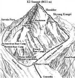
According to the Śiṣyadhīvr̥ddhidatantram its boundaries are marked as, "The land between the Malyavat (Kunlun) and the Sugandha (Greater Karakoram) mountains is called Ilāvṛta."[11]
This land, also known as Meru-varṣa, Mahakasa-varṣa, Videha-varṣa, or Maha-Videha, is the Shaksgam Valley in which Meru (K2 Mountain) resides.
Meru means Mountain, and it’s more formally known as Sumeru or Good Mountain. its other popular Sanskrit name Sudarṣana means Good Worship or Beautiful sight. It's other Sanskrit toponyms include Accha, Avatamsa, Diśādi, Girirāja, Lokamadhya, Lokanābhi, Manorama, Ratnoccaya, Śiloccaya, Suryāvarta, Suryāvarana, Svayamprabhā, Uttama, and Vidimsa. Then its Hindi name Lamba Pahar means Tall Mountain, while its Balti name Chogori means Big Mountain. Tibetan names of historical importance were Yungdrung Gutseg (Eternal Nine-Stepped Mountain) and Gangs-dkar Ti-se (Snow White Mountain.) Dapsang Is another name.
On Mt. Meru is the capital of the Divine Council of 33, Amravati, on its eastern slope. It also holds the city of Indra (Trivistapa), Vastvekasara. East of Meru itself is also another of Indra's cities, Devadhani. On another slope of Meru is Agni’s city of Tejasvi. North of Mt. Meru is Manasa. In the south, on Manasa's backside is Yama's city of Samyamana, to the west is Varuna's city Susa or Nimlocani on Manasa's peak. Siddhas and Brahmarishis are said to reside on it.[12] The collection of mountains within are known as Meruprastha.
It is said in the Matsya Purana[13] that there are two Merus; 1 on the north, which is in western Ilāvṛta-varṣa, and 1 on the south, which is west of the Niṣada Mountains. The bigger Meru is known today as the K2, while the smaller is known as Gasherbrum. In Sanskrit the taller mountain is called Sumeru (Good Meru), Mahameru (Great Meru), Hemadri (Golden mountain), Ratnasānu (Jewel peak), Karņikacala (Lotus mountain), and Deva-parvata (Mountain of the Devas.)
It's location is critical towards understanding Vedic geography as it was the ancient centre of spirituality and the crossroads of nationalities. To the west of it is Gandhamadana (Mt. Tirich Mir), to its south Kumunda (Mt. Nanga Parbat), to its east Malyavat or Mandara (Mt. Bei Tip), and to its north Suparṣva (Mt. Kongur Shan.) Another look at nearby mountains is given as Gandhamadana in the northwest, Malyavan in the northeast, Vidyutprabha (Mt. Nanga Parbat)[14] in the southwest, and Saumanasa (Mt. Saser Kangri) in the southeast.
Here were born the 4 Jain Tirthankaras; Bahu, Simandhara,
- Hari-varṣa
This is the part of India covered by the Niṣada (Karakoram) Mountains. The mountain chains are known in the Mahabharata as Nishkuta.
This is also known as Deva-Kuru, which is placed in between two mountains Niṣada and Nila. Its biggest mountain is Viktapati (Mt. Nanga Parbat), and its chief rivers are the Harita (Jhelum) and Nari (Chenab.) The sacred mountain is also known by various other names such as Vidyutprabha. The are the twin peaks Nun and Kun, which Jain scriptures call Cittakuda and Vicittakuda.
This part of Bhārata was so loved by the ancient ascetics that they wrote of it as "Bhoga-bhumi" (Land without suffering.) This is where Shambhala lies, and it includes the Olmo Lungring (Dardistan), Airyanem Vaeja (Kashmir), Tuṣita, and Satya-loka paradises. Even in the medieval times Kashmir was called "heaven on Earth." The Matsya Purana speaks of Dardistan as Tomara and Gilgistan as Hamsa-marga, and the Gilgit River which divides them both as Pavana.
Shambhala has become a very popular toponym that describes Kashmir as has been used in multiple scriptures, mainly Buddhist and Bonpa. Even today one can see the symbolism of Shambhala in placenames of Kashmir, such as of Sumbal and Sambal. Manjusrikirti the Buddhist saint is written to have been born in Shambhala (and that has father the Deva Indra was an incarnation of the Bodhisattva Sunyagarbha.) Scriptures often write of Lankapuri (the Lanka in Wular Lake) also as Shambhala. Because Shambhala is sometimes associated with areas west of it too, it's likely that the kingdom at times included those parts. Even today Ban Sumbal and Sambal are towns in Punjab just west of Kashmir. The Shambhala of Bauddh Saint Padmasambhava is within Tarbela Lake ('Dhanukosa Lake' of scriptures.)
Today, the major ethnicities that live here are Kashmiri (Kashuri), Dogra, Gujri, Shen, Gilgit, Hunza, Balti, and Hindi.
The ethnic groups known to have lived here in ancient times were Yakshas, Nāgās, Kinnaras, Vanaras, and Gandharvas. Vidyadharas was a broader ethnic category that included many of the previously-mentioned groups, such as Vanaras. Many Kashmiri Hindus have the surname 'Yaksha' or 'Yachha'. Many Kashmiri toponyms include 'Yaksha', such as Yachha-gram and Yaksha-dara. Even today, the names of Nāgās are existent in placenames, such as Nagnari, Nagbal, and Kokernag. Like the Nāgās, the Sapru are mentioned as another serpent tribe and so 'Sapru' is still a surname among Kashmiri Pandits today.
- Kimpurusha-varṣa
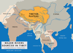
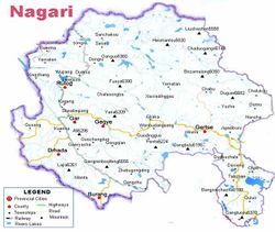
This refers to western Tibet, and is the land in between the Himalayan and the Ladakh-Gangdise mountain belts, which are known as the Mahahimavata, Herokataka Hemakuta. Kailash is the name of the Hemakuta mountain belt and of an individual mountain as well, the modern Naimona'nyi. North of it is the sacred Mainmaya (Kangrinboqe Feng), and this this northern part of the Gangdise Mountains is known as Mainaka while where the Naimona'nyi lies is the Kailash Mountains. Mt. Kailash often becomes conflated with Mt. Meru (K2), especially because their names sometimes tend to be similar. However, certain scriptures differentiate the 2; Dbra-ston mentions 2 geographical centres addressed as 'Mt. Ti-se'; 1 (Mt. Kailash) in western Tibet and the other (Mt. Meru) in sTag-gZig (Karakoram.)[15] Kailash is also known as Bonpo Bonri, Kangri, and Gangs-dkar Ti-se. The rivers flowing from Kailash are also of importance.
The region comprises of modern day portions of Tibet west of the Gangdise, as well as Uttarakhand, Nepal, Sikkim, and Bhutan. Rasātala-loka and Vitala-loka are both here.
This land is also known as Haimavata-varṣa, Hemakunta-varṣa, and Kinnara-varṣa, and Parvatiya Janapada.
The residents here are known as Parvatasrayins or Parvatiya Ayudhajivis, Mountain-dwellers. The main ethnicities of this region have been mentioned as Kinnaras, Guhyakas, and Kirati. Yakshas have also had a historical presence here. Even in modern times, just as Kashmiris carry the surnames 'Yaksha' and 'Yachha', some tribes in Nepal are identified with Yakshas, such as the Kirati Yakkha. During the Mahabharata War, Kirati king Jitedasti partook in the war on the side of the Pandavas. A powerful Kirati avatar of Shiva was Kirat whom Arjun attempted to subdue but ended up befriending.
Some of the residents here actually have surnames which symbolize Uttarakhand's history involving important persons and symbols associated with it. G(h)anshala (Shelter for Ganas), Patalia (associated with Uttarakhand being a Pātala), Dandwal (associated with the Dandaka-vana being in Uttarakhand), Dani (Descendant of Danu), Danu (Descendant of Danu), and Jalandhari (Descendant of Jalandhara) are some examples[2].
Mount Gokarna which is so sacred to Shaivism and Zoroastrianism is here, wherein today it is known as Mt. Lajia in Zanda County of Ngari Prefecture of Tibet and is measured in between 6,261m-6,332m. Other historical sacred spots include Markandaka Tirtha (also Markandasrama) at Merupada (not to be confused with Mt. Meru.)
Vitala is within Uttarakhand and although it has historically been a Pātala, it has also been addressed as "Deva-Bhumi" because of the sacred tirths present there.
Skanda was born in Krauncasaila, which is also known as both Kumaradhara and Saravana. Because this mountain is by the Ganga River, he is also known as Jahnasihuta (Son of Ganga.) Because the Guhas live here and he was one of them, scriptures also name him 'Guha' and Guhapriyā. Sacred to him are also Svamipuskarini, Skanda-vana, and Lohita-giri.
Vitala is written of in the Udyoga and Vayu Purana as the land of Asvasira (Hayagriva.[16]) He was of the Kinnara ethnicity, specifically the tribe whose totem is the horse.
Bana Daitya, although waa the son of Mahabali, and hence, a ruler of Sutala-loka, also had suzerainty over Vitala-loka. This can be seen even today with placenames in Uttarakhand, such as Banasur Ka Kila (built in medieval-era) fort in Lohaghat in Champawat district, and town of Okhimath named after Bana's daughter Usha (Okha.)[3] Bana is also believed to have had his capital, 'Shonitpur', near Kedarnath.
Bhairava was born here, and he was of the Vetal tribe. Vetala of the same tribe was also from here.
Hatkesvara, considered to be an ascetic avatara of Shiva, was the ruler of Vitala.
Virabhadra and Rudrakali were both born here to confront Daksha at the Gangadwára ashram. (The Ganga River of course, passes through Uttarakhand. Hence, the name of the ashram.)
- Bharata-varṣa
This is not the same as Bhārata but is the mainland of India, which is the part of the Indian Subcontinent south of the Siwalik Range. It is also known as Hima-varṣa because it is bound by the Himalayas. These mountains are also known as Hemaśṛṅga in the Yoga Darshana.
The varṣa is divided into 7 mountain ranges known as kulaparvatas (mountain families.) They are Mahendra, Malaya (Southern Ghatas), Paripatra (Central Indian or Dakshin Range), Riksha (Siwalik Range), Sahya, Sukimat, and Vindhya (Pir Panjal Range.)
There has been a confusion between the Vindhyas (or Vindhya-parvata) and Vindhyapada (or Paripatra.) The Varaha Purana uses "Vindhyapada" for the Central Indian Mountains while the Mahabharata uses "Vindhyapada-parvata." We know that the Pariyatras are the mountains dividing the Subcontinent into north and south because Rishi Baudhyana mentions them being the southern boundary of Aryavarta, as well as from other clues, such as the Manduka tribe's symbol being on the coins of Ujjain in central India (Pariyatra the king is mentioned as the ruler of Mandukas.) Another clue that the Vindhya-parvata is the Pir Panjal Range is from the fact that elephants are referred to as Vindhya-parvatajas (Children of Vindhya-parvata.) Elephant habitats exist in Pir Panjal and connected mountain ranges, such as the Siwalik, but not in the Central Indian mountains. That we further know elephants are native to Kashmir we can see in the Gaja Sastre (Elephant Scripture) wherein they are described as black with white spots on the head.[17]. Kishkindha is mentioned as being north of Vindhyas, to the south of which is a sea[18] (Wular Lake, wherein Lanka lies.) The 'Vindhyas' toponym has been assigned to mountains apart from the Pir Panjal arbitrarily, such as the Barabar Hills. The Pariyatra mountains are also known as Vijayardha-parvata or Vaitadhya-parvata.
The 8 upadvipas or subdivisions are: Svarva Prastha, Chandra Sukla, Avartana, Ramanaka, Manda-harina, Panchajanya, Sinhala, and Louka.
Sri Lanka is a part of the subdivisions, also known by many other names including Ceylon, Tamrapami, and Sinhala. Megasthenes, the Greek ambassador to the court of Chandragupta Maurya, grandfather of Emperor Asoka, mentioned it in his Indika under the name "Taprobane."
India is the homeland of Indo-Europeans[edit]
Before the Indo-European family of languages included European languages, the family was only Indo-Iranian, and before then, just Indo-Aryan. The homeland of the Indo-Europeans has been debated for a long time wherein most western scholarship has argued that the Aryans originated in the European Steppes or maybe in Central Asia. However, as per the genetic, linguistic, and scriptural records India is the homeland.
India is the homeland of two of the world's oldest languages, Tamil and Sanskrit. Sanskritic scriptures treat their homeland as places in India, and in the Puranic times they discuss Indians having migrated outside of the Indian Subcontinent. These migrants mentioned were mainly sages and royalty. Both the Vedic, Puranic, and Ithihasa scriptures mention invading kingdoms outside of India coming in, but these are coming into an already-existing Sanskritic and Hindu culture of India, and they embrace Hinduism in its various forms (i.e., Kanishka and Menander became Buddhists, and Heliodorus a Vaishnava.)
The Nilamata Purana states that since Prajapati is called Ka, and Kashyapa rishi is also Prajapati, the country built by him is called 'Kashmira'.
Pitṛloka, Land of the Ancestors, is headed by Agniṣvāttā, a Pitṛ (ancestor.)[19] He is said specifically to live in Somapada. It is grouped in the Mahabharata together with lands in mountainous India and eastern Uttar Pradesh.[20] The region has connections with the Himalayas in scriptures. For example, Guhyakas, who reside in and around the Himalayas, are said to visit the Somapada often. Of the Pitṛ who live in Somapada, the Devapitṛs or Agniṣvāttā children of Marichi Rishi, one of their daughters married a person named "Himavan." Warrior Vidura of the Mahabharata is said to have been transferred to Pitṛloka where he is called Yama, Yamarāja or Pitṛ-Patīn (Lord of the Pitṛs.) An important place of pilgrimage historically has been Prabhasa, where pilgrims pay homage to the ancestors. Balarama in the Mahabharata is mentioned having done just this at Prabhasa.[21] He is also said in the same part of the Mahabharata as having propitiated the ancestors at Ganga Sagara.
- Exodus of Indians
Comparison of India with other region begins in the era of King Priyavrata, son of the first Manu (Swayambhu), who had ruled all of Jambu-dvipa, and his son Agnidhra had distributed it among his sons. King Vivaswat, the son of Aditi and 1 of 12 Adityas, has many children that included 2 'Manus', Yama, Revanta, as well as others such as Kushaparva. Yama ruled in Kashmir, while Satyavrata (or Vaivasvata, Sraddhadeva) Manu resided in Ramyaka-varṣa (Central Asia in between the Amu and Syr rivers) after the flood in which Matsya helped him escape. We know that Ramyaka-varṣa was where he (along with other sages) migrated to (not where he was an aboriginal of) after the flood because the Matsya Purana mentions that he was the king of Dravida (India south of the Vindhyas) and that he had retired to the Malaya Mountains just before the flood happened. It was during the flood that Matysa helped him escape to the Himalayan highlands for refuge. Plus, the Mahabharata states, "This land (India) is the beloved one of Indra, and, O thou of Bharata's race, this land, O monarch, that is called after Bharata, is also the beloved land of Manu, the son of Vivaswat,..." Of all the flood myths in the world, there also aren't any in Central Asia, so the flood could not have happened there. Manu had the sons Vena, Drishnu, Norishyana, Navaga, Ikshvaku, Kurusha, and Sarjati who were Brahmans, Prishadhru a Kshatriya, and Nabhagarishata a Vaishya. Ikshvaku of course had his stronghold in Kosala (Uttar Pradesh.)
Neither was Ramyaka the birthplace of Manu, nor was Hiranyaksha that of Aryama. We know from scriptures that sages royalty from India many times retired in foreign lands. An example is from the story of Jain Tirthankar Parsvanath, in which Princess Prabhavati, daughter of King Prasenajit, had retiring to Ramyaka as a bhikkhuni in her plans if Parsva would choose not to marry her.
The Kurukhshetra in north-central India is a sacred land because that is where Surya established his kingdom. It is noteworthy that Sugrīva the Vanara of Kishkindha, Karna of the Kauravas, and the Ashvins were Suryaputras (Offspring of Surya.) It extended, as a janapada, from the river Sarasvati in the north to Indraprastha, the region about Delhi, in the south and from Vinashana in the south-west to Hastinapura (in Meerut district) or rather the Yamuna river in the east.
That the Hari-varṣa regions was recognized internationally as a sacred epicentre of spirituality can be seen in scriptures wherein it is given significance. For example, Bonpa scriptures call Shenaki in the Karakoram as the Olmo Lungring paradise, Mazdaen scriptures refer to Kashmir as Airyanem Vaeja, Buddhist scriptures mention Kashmir as Tuṣita, and Chinese texts of myths refer to Xiwangmu as on Mt. Meru (Jade Mountain or Mt. Kunlun.) That we see Xiwangmu the place is in Hari-varṣa is from the references to its name meaning Queen of the West in a western paradise, just as Tuṣita is the Western Paradise. Xiwangmu's messengers are also 3 blue birds just as Shenrab had descended onto Mt. Meru as a blue bird, and blue birds, such as blue magpies and blue robins, are very common in Hari-varṣa. Further, Xiwangmu's mountain of residence was encircled by 4 rivers.[22][23]
"According to a Tang scholar of the 7th century, Daoxuan (596-667), "Kunlun" and Himalaya were one and the same. Many scholars suspect the Chinese legend of "Xiwangmu" being a goddess of Indian origin, albeit it is difficult to convince others without historical evidence."[24]
Northern[edit]
- Ketumala-varṣa (Afghanistan)
| Ketumala-varṣa indeed extends from Romakapura to [the] Gandhamadana [mountain]. | ||
—Srimad Bhagavatam | ||
The prominent mountain associated with this continent is Gandhamadana Mountain. It is the modern-day Tirich Mir[25] because the Mahabharata identifies Mt. Meru as being between Mt. Malyavat and Mt. Gandhamadana.[26] Ketumala is also called Amara-Gandika or To the west of the Gandika (Mt. Gandhamadana.)
The golden Asvattha tree is said to be on the summit of Mt. Gandhamadana. Outside of Mt. Meru, this was the favorite mountain for siddhas to take recluse.
According to the Śiṣyadhīvr̥ddhidatantram, Mt. Gandhamadana is on the side of the Niṣada (i.e., where the Karakorum ends.)
| Close to the Gandhamadana, along the banks of Apara-Gandika, is the county of Ketumala, 34,000 yojanas in length, and 32,000 broad. | ||
The Apara-Gandika referred to in the above verse is the Kunar-Chitral River which is by Mt. Gandhamadana.
Outside of the Subcontinent, this place was so popular that it had been written as the "Dhvajavati-kanya of Rishi Harimedhas."[27]
The land was also known as Gandhamadana-varṣa, Apara-Godaniya (Apara-Goyana), Apara-Videha, and Uttar-Videha.
- Ramyaka-varṣa (northeastern Afghanistan, Tajikistan)
| Sanjaya said, "On the south of Sveta and the north of Niṣada, is the varṣa, called Romanaka." | ||
The land south and including the mountain range that is known by the names Sveta, Shukla, or Rukmi (Pamirs), and the north of Niṣada (Karakoram) is known as Ramyaka, and by other variants of the same name, such as Ramaniyaka and Romanaka.
This is also known as Hiraijyaka-varṣa because not only does this border the Sveta and Niṣada mountains, but the Nila Mountains as well. Hence, it is also called the Nilachala-varṣa. It is also mentioned as Camakara-varṣa in the Vamana Purana.
This is where Jain Prince Nagakumara of Magadha traveled to after traveling and marrying in Kashmir. Here he confronted and defeated an Asura named Bhima. In the country he then met King Vanaraja of Giri-Sikhara-nagara city. The monarch offered his daughter, Laxmimati in marriage to Nagakumara and so they wedded. He found and worshiped in a Jain temple here too.
The tallest mountain, Ismael Somoni Peak is also known as Vipula.
According to the Śiṣyadhīvr̥ddhidatantram, Mt. Vipula is on the other side surrounding the mountain Meru.
- Hairanyavata-varṣa (southern Uzbekistan and southern Turkmenistan)
It is also known as Hiranmaya and Hairanvata.
- Uttara-Kuru (Kazakhstan, Northern Kyrgyzstan, and northern Uyghurstan)
The Matsya Purana[28] places the source of the Sailoda (Syr Darya) in the Aruna (Tien Shan) Mountains. But according to the Vayu Purana[29] this river had its source in a big lake lying at the foot of Munjavata Mountain (Jengish Chokusu.) This river flowed between the rivers Chakshu (Amu Darya) and Sita (Tarim River) which emptied in the Lavanodadhi or Salt Sea (Aral Sea.)
Uttara-Kuru is also known as, Kuru-varṣa, Shringa-varṣa, and Uttarardha-Vijaya. The Aruna Mountains are also known as the Sikhari or Shringa mountains. These mountains are also known as Tri-Shringa because they have 3 great peaks; Communism Peak, Lenin Peak, and Khan Tengri. The biggest peak is Khan Tengri.
Sometimes Ramyaka-varṣa is included as an extension of Uttara-Kuru, as in most Jain and Buddhist scriptures wherein Ramyaka-varṣa isn't even mentioned, but Uttara-Kuru along with Bhārata, Ketumala, and Bhadrasva are.
It is evident that the peoples of the this region in the ancient times had also referred to themselves as Kurus because of local demonymns such as the Kuramin Mountains in southern Uzbekistan and northwestern Tajikistan, and the Kurutag Range in northern Uyghurstan.
Here is where Jain Tirthankara Nami took diksha in the Caitra-vana garden on the night of Asadha.[30] Rishabha used to feed on fruits of the kaipadruma brought to him by the gods. The 7th avatar of Rishabha is said to be as twins in Uttara-Kuru.[31]
According to the Śiṣyadhīvr̥ddhidatantram, Mt. Suparṣva is on the side of the Nila (i.e., on the edge of the Hindu Kush.) Interestingly, the Padma Purana mentions that there is a Narayana shrine on this Suparṣva.[32]
- Bhadrasva-varṣa (Tarim Basin)
| It is said that Bhadrasva-varṣa extends from the city of Yamakoti up to the Malyavat Mountain. | ||
—Srimad Bhagavatam | ||
The prominent mountain associated with this continent is Malyavat Mountain. It is the modern-day Muztag (7,282m) along the Yurungkax He stream by the Anila (Kunlun) Mountains because the Mahabharata identifies Mt. Meru as being between the Mt. Malyavat and Mt. Gandhamadana.[33]
Bhadrasva is also known as Bhadraturang, Malyavat-varṣa, Vijaya, and Purva-Videha.
The Bhagavata Purana[34] says that it possess 7 mountain ranges; The Sukla, Vardhamana, Bhojana, Upabarhana, Nanda, Nandana, Sarvatobhadra. Its 7 major rivers are Abhaya, Amritaugha, Aryaka, Tirthavati, Rupavati, Pavitravati, and Sukla.
According to the Yoga-Vasiśṭha of Valmiki, Krauncha-dvipa is bounded by the sweet Saccbariue Sea, and beset by a range of mountains.
| Mandara is at the edge of the Himalayas where the Malyavan Mountains begin. | ||
—Padma Purana | ||
Here, the root of the Himalayas extends as far as the eternal Mandara (Mt. Bei Tip), which is known for having the popular Deva-Asura tug-of-war, and the 12th Jain Tirthankara Vasupujya attained Nirvana here[35], and the Garuda Anadrta lives here in a siddhayatana.[36] It is mentioned by the Thanangasutra and Samvayangasutra as having Mt. Malyavan to its northeast[37], it being south of Mt. Gandhamadana, and has Badarikashrama to its south. The closest river to it is the Rajatamulika.
According to the Śiṣyadhīvr̥ddhidatantram, Mt. Mandara is on the side of the Malyavat.
| O Mandara, since you look charming with Caitraratha and Bhadrasva, therefore give (me) happiness. | ||
—Padma Purana | ||
Here was the famous Caitrarathavana garden, which is accord with the Kurma Purana was east of Ilāvṛta-varṣa. The Brahma Purana mentions it on Mt. Chandraprabha, while the Bhagavata and Matsya Puranas on Mt. Mandara, Vayu Purana at Acchoda River, and Vispupurapa mentions it at Alaka.
Mandarajinabhavana refers to Jain shrines at Mount Mandara, as it was a sacred place of pilgrimage for many.
Division into 7 continents[edit]
According to the Avesta, the world island is divided into 7 continents or “Keshvar”. Their names are: (1) Arezahi (Southwest Asia) to the west, (2) Savahi (East Asia) to the east, (3) Fradadafshu (Africa) to the southwest, (4) Vidadafshu (Indochina, Indonesia, and Australasia) to the southeast, (5) Vouru-Bareshti (Europe) to the northwest, (6) Vouru-Jareshti (Siberia) to the northeast, (7) Khvaniratha (Maha-Jambu-dvipa) in the centre of the mentioned six regions.
Sāka-dvipa[edit]
This continent is located northeast of Sudarṣana-Dvipa. It refers to Northeast (lands West of Ural Mountains) Asia beginning from the Indus River.
Its varṣas are Jalada, Kumara, Sukumara, Manivaka, Kusumoda, Maudaki, and Mahadruma.
Those varṣas' corresponding mountain chains are Udayagiri, Jaladhara, Raivataka, Syama, Ambikeya, Ramya, and Kesarin.[38]
Its 7 sacred rivers are the Sukumari, Kumari, Nalini, Dhenuka, Ikshu, Venuka, and Gabhasti.
Krauncha-dvipa[edit]
- See also: The spread of Hinduism in East Asia
This continent is located east of Sudarṣana-Dvipa. It refers to East Asia.
Sālmali-dvipa[edit]
The Yoga-Vasiśṭha[39] mentions this continent as Sveta-dvipa (White Island.) In some descriptions of Sālmali-dvipa, Sveta-dvipa is actually included as a part of the continent.
Kuṣa-dvipa[edit]
This is Africa.
The continent is named after the Kuṣa grass (desmostachya bipinnata), which, outside of India and S.W. Asia, is abundant in North Africa particularly.
Plakṣa-dvipa[edit]
This refers to Southwest Asia. It is also known in scriptures, such as Yoga-Vasiśṭha[40] as Gomeda.
It is said to surround Jambu-dvipa.[41] It is also said to possess the plakṣa or fig plant (Ficus carica) after which it is named. The plant is native to the S.W. Asia.
Puṣkara-dvipa[edit]
This refers to Southeast Asia.
The Srimad Bhagavatam mentions that this region is affiliated with the lotus flower[42] (Nelumbo nucifera), which is found throughout S.E. Asia. The scripture also mentions the region Puṣkara-dvipa's association with the mango tree, which is found in S.E. Asia. The Srimad Bhagavatam also mentions Puskara-dvipa's effects of the equinox in relation to its northern and southern halves.[43] In fact, the mountain said to divide these 2 is called Mānasottara. This today, is the Mount Kerinci volcano on Sumatra Island, which is just 1°41′48″S of the equator. There are also said to be elephants here.[44] Elephants outside of India are of course, only found in Africa and S.E. Asia.
The ruler of this island, the son of Mahārāja Priyavrata named Vītihotra, had two sons named Ramaṇaka and Dhātaki. He granted the two sides of the island to these two sons and then personally engaged himself in activities for the sake of the Supreme Personality of Godhead like his elder brother Medhātithi.
Concept of the Chakravarti[edit]
- See also: Chakravarti
The Chakravarti (Wheel-turner) was a ruler whose domain included vast regions. There are different kids of Chakravartis mainly the Chakravartis or emperors of India, and the Ardha-Chakravartis or Half-Chakravartis that ruled only half of India.
See Also[edit]
- The spread of Hinduism
- Historical racial diversity of Hindus
- Yama's Kingdom is in Kashmir
- Ravana's Lanka is in Kashmir
- Hanuman's Kishkindha is in Kashmir
- Zarathustra was born in Kashmir
- Olmo Lungring is in Karakoram
- Kingdoms of Asura Dominance
- Modern identification of Rig Vedic rivers
- Origins
- Yungdrung Bon For The World
- Jainism Beyond India
External Resources[edit]
References[edit]
- ↑ Kashmir under Karkota Dynasty's rule had annexed neighboring areas of Punjab and Afghanistan and even after Karkota rule Takshshila was virtually a tributary to Kashmir; P. 59-60 Kashmir and It's People: Studies in the Evolution of Kashmiri Society By M. K. Kaw
- ↑ P. 71 Bharātīya Vidyā, Volumes 22-24 By Bharatiya Vidya Bhavan
- ↑ Mahābhārata Shanti-parva Section VI: "The huge mountains of Hemakuta are otherwise called Kailasa."
- ↑ Vishnu Purana 2.3.1
- ↑ Vasiśṭha Sutra 1.15
- ↑ Chapter 3, Verse 48b–49c
- ↑ P. 103 Prāci-jyotī: Digest of Indological Studies, Volume 8 By Kurukshetra University
- ↑ Vishnu Purana Book 2, Chapter 3
- ↑ "Svarnaprastha, Candrasukla, Avartana, Raman aka, Mandara Harina, Pancajanya, Simhala and Lanka."; P. 270 The Process of Creation in Dasa Sahitya By Vi Bādarāyaṇamūrti
- ↑ Puratan Janam-sakhi and Siddha Goshti
- ↑ P. 261 Śiṣyadhīvr̥ddhidatantram: Translation and mathematical notes By Lallācārya, Mallikārjuna Sūri
- ↑ Matsya Purana 114.83-84
- ↑ Matsya Purana 113.20
- ↑ In legends, Vidyutprabha was Vidyadhara lord of the hill of Kálanjara, who attacked Prabhása. Vidyadharas lived around the Karakoram and Pir-Panjal ranges.
- ↑ P. 284 Sacred Spaces and Powerful Places in Tibetan Culture: A Collection of Essays By Toni Huber
- ↑ Udyoga 99-5; Vayu 50.21
- ↑ P. 51 Spolia Zeylanica: Geology, zoology, anthropology By Colombo Museum
- ↑ Ramayana IV-46. 17
- ↑ Srimad Bhagavatam 5.26.5
- ↑ Mahabharata Vanaparva SECTION LXXXIV "One should next go to Somapada, with subdued soul and leading a Brahmacharya mode of life."
- ↑ Srimad Bhagavatam 10.79.19-21
- ↑ P. 162 Handbook of Chinese Mythology By Lihui Yang, Deming An, Jessica Anderson Turner
- ↑ P. 124 Res: Anthropology and Aesthetics, 61/62: Spring/Autumn 2012: Sarcophagi By Francesco Pellizzi, Hung Wu, Jaś Elsner
- ↑ Wild Goose (Dayan) Qigong: Bibliography, Links, Resources ...
- ↑ This geographic references of this mountain are more obscure than others because it is claimed in some texts like The Súrya Siddhánta to be north(west) of Romakapattana (modern-day Badakshan) but in others to be south(west) of it. In Mahabharata it’s said to be north of Malyavat.
- ↑ Mahabharata Shantiparva Section VI: "Beyond Malyavat northwards is the mountain called Gandhamadana. Between these two (viz., Mt. Malyavat and Mt. Gandhamadana) is a globular mountain called Meru made of gold."
- ↑ Mahabharata Udyogaparva 108.13
- ↑ Matsya Purana 120, 19-23
- ↑ Vayu Purana 47, 20-21
- ↑ P. 170 Jainism in South India P. M. Joseph
- ↑ P. 63 The Jain Saga - Part 1: Brief history of Jainism : story of 63 illustrious persons of the Jain world By Kalikaal Sarvagya Hemchandrasuriswarji
- ↑ P. 2831 The Padma-Purana Part 8: Ancient Indian Tradition and Mythology Volume 46 By Dr. G.P. Bhatt and Dr. N.A. Deshpande
- ↑ Mahābhārata Shantiparva Section VI: "Beyond Malyavat northwards is the mountain called Gandhamadana. 4 Between these two (viz., Malyavat and Gandhamadana) is a globular mountain called Meru made of gold."
- ↑ Bhagavata Purana V.XX.20-22
- ↑ P. 148 Jaina-rūpa-maṇḍana: (Jaina iconography). 1 By Umakant Premanand Shah
- ↑ P. 38 Elements of Jaina Geography: The Jambūdvīpasaṃgrahaṇī of Haribhadra Sūri : Critically Edited and Translated with the Commentary of Prabhānanda Sūri By Haribhadrasūri, Frank Van Den Bossche
- ↑ P. 114 Geography of the Mahabharata By Bhagwan Singh Suryavanshi
- ↑ Mahābhārata Bhumi Parva SECTION XI
- ↑ Yoga-Vasiśṭha 3. 73.53-8
- ↑ Yoga-Vasiśṭha 3. 73.53-8
- ↑ SB 5.20.2
"As Sumeru Mountain is surrounded by Jambūdvīpa, Jambūdvīpa is also surrounded by an ocean of salt water. The breadth of Jambūdvīpa is 100,000 yojanas [800,000 miles], and the breadth of the saltwater ocean is the same. As a moat around a fort is sometimes surrounded by gardenlike forest, the saltwater ocean surrounding Jambūdvīpa is itself surrounded by Plakṣadvīpa. The breadth of Plakṣadvīpa is twice that of the saltwater ocean — in other words 200,000 yojanas [1,600,000 miles]. On Plakṣadvīpa there is a tree shining like gold and as tall as the jambū tree on Jambūdvīpa. At its root is a fire with seven flames. It is because this tree is a plakṣa tree that the island is called Plakṣadvīpa. Plakṣadvīpa was governed by Idhmajihva, one of the sons of Mahārāja Priyavrata. He endowed the seven islands with the names of his seven sons, divided the islands among the sons, and then retired from active life to engage in the devotional service of the Lord." - ↑ SB 5.20.29
"Outside the ocean of yogurt is another island, known as Puṣkaradvīpa, which is 6,400,000 yojanas [51,200,000 miles] wide, twice as wide as the ocean of yogurt. It is surrounded by an ocean of very tasteful water as broad as the island itself. On Puṣkaradvīpa there is a great lotus flower with 100,000,000 pure golden petals, as effulgent as the flames of fire. That lotus flower is considered the sitting place of Lord Brahmā, who is the most powerful living being and who is therefore sometimes called bhagavān." - ↑ SB 5.20.30
"In the middle of that island is a great mountain named Mānasottara, which forms the boundary between the inner side and the outer side of the island. Its breadth and height are 10,000 yojanas [80,000 miles]. On that mountain, in the four directions, are the residential quarters of demigods such as Indra. In the chariot of the sun-god, the sun travels on the top of the mountain in an orbit called the Saṁvatsara, encircling Mount Meru. The sun’s path on the northern side is called Uttarāyaṇa, and its path on the southern side is called Dakṣiṇāyana. One side represents a day for the demigods, and the other represents their night." - ↑ SB 5.20.39
"On the top of Lokāloka Mountain are the four gaja-patis, the best of elephants, which were established in the four directions by Lord Brahmā, the supreme spiritual master of the entire universe. The names of those elephants are Ṛṣabha, Puṣkaracūḍa, Vāmana and Aparājita. They are responsible for maintaining the planetary systems of the universe."

